
About This Tour:
The Santa Fe Trail (SFT) was a two-way trail between the US and New Mexico in use from 1821 through the 1870’s. It began as a trading route with wagonloads of goods traveling in both directions along the trail. The SFT was 800-900 miles long and took about 8 weeks to travel.
Douglas County is fortunate to have 5 MILES of the ACTUAL SANTA FE TRAIL still in use as roadway today. The remainder of the county’s trail runs very close to the roads and many wagon ruts can be seen. Since the SFT route goes through rural areas and cell phone reception can be spotty, it is recommended that the rider download the map before beginning the tour.
Find more information about the SFT at Detailed Pictorial Tour of SFT
Start of Tour: A – Black Jack Ruts and Ivan L. Boyd Memorial Prairie Preserve – 2011 N 200 Road, Wellsville, 66092
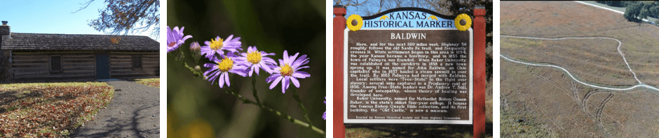
Introduction: This site contains many of the deepest ruts (or swales) left by the wagons traveling on the Santa Fe Trail (SFT). Several of these ruts are easily seen from the gravel walking trail that loops around and THROUGH the ruts. Informational signage and a free audio tour using the listener’s cell phone are on site. The site contains 18 acres of native tall grass prairie, unique to the eastern end of the trail. Further historical signage on site relates to early local history, pioneer history and Bleeding Kansas history. (“Bleeding Kansas” refers to the violent disagreements between pro-slavery and free state supporters as Territorial Kansas settlers determined whether their state would enter the Union as a free or slave state.) A replica pioneer log cabin is also at the site.
Backstory: The Black Jack Ruts and Ivan L. Boyd Memorial Prairie Preserve are only some of the features at this site. Historical Markers and Signage and a Replica Pioneer Log Cabin are also at this site.
Black Jack Crossing: This area was called Black Jack Crossing. Its use began in the early days of the trail (1820’s). Santa Fe Trail (SFT) travelers camped here on the second night of their journey from Independence, MO since the creek was a good source of water. They camped outside of Olathe in Johnson County, KS on their first night. The creek may have been named called Black Jack by the Mexican wagon train drivers because of the Black Jack oak trees that grew along the creek. The creek was much larger and wider in the trail days. It has been greatly altered by farming and roadwork. It is now called Captain’s Creek.
SFT travelers traveled 15 to 30 miles per day depending upon the circumstances and difficulties they encountered. Black Jack Crossing was 65 miles from Independence, MO. The travelers crossed Black Jack Creek to the west and northwest of this site then went northwest to the ridge called “The Narrows.” Wagons navigated the ridge to avoid having to cross multiple waterways. This ridge led to what was later the town of Palmyra and on to the current N. 400 Rd.
The wagons traveling the SFT were very heavy. They were loaded with goods for trading such as cloth, tools, needles and thread. Each teamster’s food for the trip was carried in the wagon – flour, bacon, sugar, rice, beans – 160 pounds per person. The wagon owners paid a tax per wagon when they reached Santa Fe, so freighters tried to carry as many goods as possible in each wagon. The average wagon carried 2.9 tons of freight. These wagons left deep ruts along the trail. The SFT at Black Jack Crossing was well-used. A six-month survey in the 1850’s counted 4,472 wagons, 1,261 horses, 6,452 mules, 32,281 oxen, with an estimated 13,056 tons of freight passing along the trail during that time period.
Black Jack Wagon Ruts: This roadside park site contains five very impressive ruts (some nearly 4 feet deep), as well as several lesser ruts, all left by wagons using the SFT between 1821 and the 1870’s. The new gravel Wagon Ruts Walking Trail was created in 2021. It loops around and THROUGH the ruts. (NOTE: Each rut was made by one wagon.) Informational signage and a free audio tour using the listener’s cell phone are on site.
Ivan Boyd Memorial Prairie Reserve: The eastern part of the SFT crossed through the tall grass prairie. This prairie reserve site contains 18 acres of native prairie. The site has been owned by Douglas County since 1967, when it was purchased from Russell Hays. The roots from the tall prairie grasses may extend 30 feet below the soil. This depth enables them to survive droughts and fires. Over 230 species of plants have been documented here.
The beauty of the tall grass prairie was noted by many trail travelers, both male and female, in their diaries and reports. The look of the prairie changes from month to month and season to season with a variety of plants, flowers, and insects on display. By late summer, the grasses are up to 6 feet high. Our publication, Plants of the Black Jack Prairie 2nd Ed, 2024, SFTHS, contains information and pictures about the prairie. (It can be read and/or downloaded from the link.)
This entry from the 1846 diary of Susan Shelby Maggofin reflects the thoughts of many travelers.
“At night we struck camp at ‘Black Jack,’ fourteen miles from the last [campsite, Lone Elm], and 49 from Independence. The sun was an hour high when we stopped and as the wagons had not come up we could not strike camp. Being tired of the carriage I got out and took a ramble. I picked numberless flowers with which the plains are covered, and as mi alma [her husband] told me before we started, I threw them away to gather more.” – Susan Shelby Magoffin – 18461
Historical Markers and Signage: This roadside park also has two large historical markers. One describes the Battle of Black Jack, which occurred ½ mile to the south, and the other relates the history of Baldwin, which is 3 miles west on US 56. The granite Daughters of the American Revolution (DAR) marker was originally placed by the DAR at the Black Jack Town Site, ½ mile to the east. The green metal sign describes the 18 acres of native prairie, which includes the wagon ruts. This sign is one of a dozen or so informational signs that Amelia Betts and Katharine Kelly, local historians, erected in the 1980’s with their own money along the SFT.
Replica Pioneer Log Cabin: The replica pioneer log cabin was built by Santa Fe Trail Historical Society of Douglas County members beginning in 1970 and was dedicated in1971. It was built in the style of cabins used in pioneer days in the Black Jack area. The cabin contains articles and tools from pioneer times. It is open by appointment.
Find further information about all aspects of this site at Black Jack Area
- Magoffin, Susan Shelby, Down the Santa Fe Trail and into Mexico: The Diary of Susan Shelby Magoffin, 1846-1847, ed. Stella M. Drumm, (New Haven: Yale University Press, 1962).
(Not On Tour) A-1 – Black Jack Cemetery and Town Site
Introduction: This site is best to read about than visited since it is very difficult to find and has not much to see. The town of Black Jack was located along the Santa Fe Trail (SFT). The small cemetery is all that remains of the town. The SFT was the main road through the town. After the Kansas Pacific Railroad was completed through Wellsville (several miles south) in 1870, most commercial interests abandoned Black Jack and moved to Wellsville.
Backstory: The town of Black Jack was located 4 miles east of Baldwin and ½ mile south of current US 56. Immigrant settlers were here as early as 1852 although the territory was not officially open to settlement until 1854. In 1857 about ten local men formed a company and petitioned the government to survey a town site. The site was made up of 40 acres divided into 20 blocks and located on the divide between the Kansas and Marais des Cygnes Rivers.
The town took its name from Black Jack Crossing, located ½ mile to the west (see site A). The first building in Black Jack was a hotel built in 1851. By 1860 there were 3 blacksmith shops, 2 stores (one with the post office), the hotel, a boarding house, a wagon shop, a crudely built fort in case of attack, a druggist, a doctor’s office, 2 school buildings, 3 churches, and a stage station that was served by stage coaches from Paola to Lawrence and from Kansas City to Lawrence.
The main road through Black Jack was the Santa Fe Trail. Some years 60,000 teams travelled through town on the SFT. The cemetery was planned in 1874 for 90 graves and is all that remains of the town today. After the Kansas Pacific Railroad was completed through Wellsville (several miles south) in 1870, most commercial interests abandoned Black Jack and moved to Wellsville.
Bleeding Kansas Events: The town of Black Jack has a tie to several events in the history of Bleeding Kansas. In August 1862, Bill Anderson attacked the town. In May 1863, Dick Yeager made a memorable visit.
Find further information about this site at Black Jack Area
B – Black Jack Battlefield – 163 E. 2000 Rd, Wellsville KS 66092
Introduction: The Black Jack Battlefield, as well as the Santa Fe Trail (SFT) wagon ruts to the northeast, were the site of what many consider to be the first battle of the Civil War. The creek along which the fighting occurred is the same creek the SFT travelers passed over at Black Jack Crossing. The battle between pro-slavery troops led by Captain Henry C. Pate and free state forces led by John Brown occurred in the early morning hours of June 2, 1856. Signage about the battle and several miles of nature trails can be explored on the property.
Backstory: The Battle of Black Jack is considered by many to be the first battle of the Civil War. It is part of Bleeding Kansas history. This site is ½ mile south of the Black Jack ruts (site A). The creek along which the fighting occurred is the same creek the SFT travelers passed over at Black Jack Crossing. SFT wagon ruts have been found on this property.
In the early morning hours of June 2, 1856, abolitionist John Brown and 29 free state men advanced against the pro-slavery forces of Captain Henry C. Pate camped on this site. The five-hour battle concluded by tricking Capt. Pate into believing Brown’s forces were much larger than they were. Pate surrendered. Three days later Pate and his men were turned over to Colonel E.V. Sumner from Fort Leavenworth at Trail Park just west of Palmyra. These men were then released to other leaders of the Missouri border ruffians and sent back to Missouri.
Robert Hall Pearson fought in the battle alongside Brown. After the war Pearson bought 200 acres where the battle was fought. In the 1880’s he built a farmhouse on the site. Signage about the battle and several miles of nature trails can be explored on the property. Various accounts of the battle have been written by participants and can be found in books, old newspapers, governmental documents, and online.
C – Palmyra Well – 400 Washington Street, Baldwin City, 66006
Introduction: The Palmyra Well was a 70 ft. deep hand-dug well built prior to 1857 and was part of the town of Palmyra. It provided a reliable source of water to the many travelers along the Santa Fe Trail (SFT). The current structure was built in 2010. The site has a new illustrated sign with information about the SFT, well, and town of Palmyra.
Back Story: The Palmyra Well was a 70 ft. deep hand-dug well built prior to 1857 and was part of the town of Palmyra. It provided a reliable source of water to the many travelers along the Santa Fe Trail (SFT) as well as to the residents in the area. Trail travelers used it for watering livestock, washing clothes, and cooking meals. The well and Blood’s Grocery Store and Post Office to the west were the main meeting places in town.
Earliest photos show an open wooden box around the well with a simple cross bar to pull up the buckets of water. No roof was present. The current structure was built in 2010 to enclose the well for liability issues. Several years ago, the well measured 2 ½ ft. in diameter, 56 ft. deep with 17 ft. of water.
D – Palmyra Townsite DAR Marker – in front of 400 Eisenhower St., Baldwin City, KS 66006
Introduction: The town of Palmyra was located along the Santa Fe Trail (SFT). It was founded in 1855 and included the Palmyra Well, an important water source for trail travelers. It was an important repair and rest stop along the SFT. The Daughters of the American Revolution (DAR) marked the townsite with a granite marker at this location. A green informational sign tells the history of the town. The well and the DAR marker are all that remain on this site of Palmyra.
Backstory: The town of Palmyra was located along the Santa Fe Trail (SFT). It was founded in 1855 and included the Palmyra Well, an important water source for trail travelers. Palmyra was an important repair and rest stop along the SFT. It was mapped to be 8 blocks wide and 12 blocks long, with 4 city parks. The town included Stephen’s Store and Santa Fe Hotel, Bodwell’s and Webster’s Blacksmith Shops, Blood’s Grocery Store and Post Office, Fager’s Wagonmaker’s Shop, Johnson’s Harness Shop, Goodin’s Law Office, Westrall’s Drug Store, a sawmill, and Palmyra Well.
Blood’s Grocery Store and Post Office was a community meeting place. Townspeople gathered there and at the Palmyra Well (one block east) to share news and information. In the 1980’s, local historians Katharine Kelley and Amelia Betts placed a green informational sign at this site, close to where Blood’s Store was originally located in Palmyra. A typical granite DAR marker is also at this site. Blood’s Grocery Store and Post Office was relocated several times and is now located next to Old Castle Museum at 511 5th St. in Baldwin. It was restored in 2019 and is open by appointment by contacting archives@bakeru.edu.
E – Trail Park & The Narrows – West side of 6th St./E.1700Rd./Do. Co. 1055 at N. 400 Rd (Road angles to northwest)
Introduction: Trail Park was located along the Santa Fe Trail (SFT) and is adjacent to a small stream that was sometimes called Cut Off Crossing. The site also leads to the first section of the original route of the SFT – the ACTUAL SFT- on which you will drive. This trail section leads to a higher part of the Narrows, used by SFT wagons. The Narrows follows a thin narrow ridge between the tributaries of two rivers. The wagons needed to follow this ridge to avoid having to cross multiple waterways so they would not get stuck in the mud. On the rest of the tour, the rider will be on or close to the actual SFT in Douglas County. Trail Park is the site of further Bleeding Kansas history related to the Battle of Black Jack.
Backstory: Trail Park: Trail Park was located along the Santa Fe Trail (SFT) and is adjacent to a small stream that was sometimes called Cut Off Crossing. The stream began at the upper reaches of Ottawa or Tauy (pronounced “Toy”) Creek. In the time of the trail, the creek would have been shallow with barely noticeable banks and easily crossed. It would also have had timber along it for use as firewood for camping.
At this site on June 5, 1856, three days after the Battle of Black Jack (site B), free stater John Brown turned over his prisoners, Capt. Henry C. Pate and 22 of his men, to Colonel E.V. Sumner of Fort Leavenworth. Col. Sumner handed the prisoners over to leaders of the Missouri border ruffians who then sent pro-slaver Pate and his men home.
The site contains a large granite Daughters of the American Revolution (DAR) marker, a wooden sign, and a green metal sign erected in 1983 by local historians Katharine Kelley and Amelia Betts. The DAR marker originally contained a large bronze plaque which was stolen in 1967 and replaced with a marble plaque in 1969. The Trail Park is owned and managed by Baker University and is listed as a National Historic Landmark.
The Narrows: The angling road on the left is part of the original route of the Santa Fe Trail (SFT) – the ACTUAL SFT- on which you will drive. This trail section leads to a higher part of the Narrows. The Narrows is a term used for the thin narrow ridge that is the highest point between the tributaries of the Wakarusa and Kansas Rivers to the north and the Marais des Cygnes river to the south. The wagon trains followed this ridge because it decreased the number of creeks and streams they would need to cross. Encountering fewer creek crossings and less water on the trail reduced travelers’ chances of getting stuck or damaging wagon wheels and axles.
The need to follow the Narrows is the reason the SFT bends to the north and then back south as it moves across Douglas County.The Narrows has no specific beginning or end but started at roughly the Douglas County line on the east and ended close to Overbrook on the west. On the rest of the tour, the rider will be on or close to the actual SFT in Douglas County.
At the corner of N 400 and E 1600 Rd (the next corner) you will be looking north to the trail crossing about ¼ mile up the road and will notice the huge incline in the roadway to reach the top of the Narrows
The Trouble with Water: Although the ridge of the Narrows was high, and stream crossings were few in Douglas County, water could cause much difficulty. Earlier, it was noted that SFT wagons tried to travel 15-30 miles each day. Black Jack Crossing, 65 miles west of the starting point of Independence MO, was commonly a camping spot for the second night on the trail. Due to difficulties with water, some travelers took 1-2 days to cross just 9 miles of the Narrows between Black Jack and Willow Springs. This section was the wettest part of the Narrows.
Parts of the Trail dipped into lower areas of ground. Even areas that appeared dry and easily crossable could be tricky as noted by travelers along the Trail. Commonly, a wagon would sink to the axel hubs in mud, while the surface of the soil all around would appear perfectly dry and smooth. Josiah Gregg, a trader who crossed the trail multiple times between 1831 and 1840, called the area “…a region of troublesome quagmires.”
Some travelers on the Trail noted their reaching, or passage through The Narrows – especially getting stuck.
“…it is quite common for a wagon to sink to the hubs in mud, while the surface of the soil all around would appear perfectly dry and smooth. To extricate each other’s wagons we had frequently to employ double and triple teams, with ‘all hands to the wheels’ in addition – often led by the proprietors themselves up to the waist in mud and water.” – Josiah Gregg, a trader 1831-18401
“The hindermost one [wagon] has stuck in a mud hole and they are doubling and tripling teams to pull it out… We have made but a poor travel to day; not more than eight miles…. the mud hole detained us two full hours; so to make up in some measure we did not stop until after 8 o’clock tonight.”…– Susan Shelby Magoffin – 18462
Find more information about the Narrows at The Narrows
- 1.Gregg, Josiah, Commerce of the Prairies, ed. Max. L. Moorhead, (Norman: University of Oklahoma Press, 1974).
- 2.Magoffin, Susan Shelby, Down the Santa Fe Trail and into Mexico: The Diary of Susan Shelby Magoffin, 1846-1847, ed. Stella M. Drumm, (New Haven: Yale University Press, 1962).
F – Hickory Point & The Coleman-Dow Incident – About 1520 N. 500 Road
Introduction: Hickory Point was a very short-lived community along the Santa Fe Trail (SFT). Locals were a mixture of free staters and pro-slavery supporters. The Coleman-Dow incident, which involved the murder of Dow by Coleman, led to the eventual end of the town. The incident sparked a great deal of controversary in the area and is another part of Bleeding Kansas history. An informational sign is at the site.
Backstory: Hickory Point was a very short-lived community along the Santa Fe Trail (SFT). It contained a blacksmith shop, store, community well, and a post office. Locals were a mixture of free staters and pro-slavery supporters. The Coleman-Dow incident led to the demise of the community.
The site has a white informational sign. Just past the sign, to the west (left), about 100 yards out in the pasture, are faint wagon traces. The sign, townsite, ruts, and pasture can be observed from the road only since they are on private property, so off-limits to visitors.
Coleman-Dow Incident: On November 21, 1855, Free-Stater Charles Dow was shot and killed by pro-slaver Franklin Coleman near this corner on the road from Hickory Point.
Dow and Coleman had been arguing over the boundary of their adjacent properties. One day, Coleman was cutting trees on the disputed strip of land. Dow told him to leave the property. Coleman began cutting wood a second time. Dow saw him and told him to stop. They again argued over the boundary lines. Dow went to his neighbor Jacob Branson and asked for his help, but they could not find Coleman. Dow left Branson and headed for home. On November 21, 1855, Dow and Coleman ran into one another along this road and an argument ensued. Coleman shot Dow, which killed him, and left him on the road. At the end of the day his body was discovered by a neighbor named Gleason.
Coleman fled to the Shawnee Mission (in Johnson County KS) and gave himself up to Gov. Wilson Shannon. Sheriff Sam Jones of Lawrence, a pro-slaver, swore out an arrest warrant for Branson because he was an important witness to this murder, and as a friend of Dow’s, would undoubtedly testify for the prosecution of Coleman. On November 26, Jones and his posse were heading south to arrest Branson. At 11 p.m. they arrived at Branson’s cabin, knocked, then burst through the door without waiting for a response. They dragged him out of bed, forced him to dress, and placed him on a mule. The posse headed for Lecompton by way of Lawrence.
Jones and his men may have crossed Blanton’s Bridge on their way out of Lawrence to arrest Branson. Blanton went ½ mile south to warn his neighbor James B. Abbott. Others collected at Abbott’s place and when the posse was returning to Lawrence about midnight with their prisoner, the group stopped them. Abbott and the others were able to rescue Branson. Jones and his posse did not counterattack, but after some argument, headed back to Lawrence across the Blanton Bridge. These events led to the famous Wakarusa War.
G: Brooklyn Town Site DAR Marker and Quantrill’s 1863 Raid – East corner of E. 1400 and N. 550 Rds.
Introduction: Brooklyn was a town along the Santa Fe Trail (SFT) established as early as 1855. The SFT went through the town. It was destroyed by Quantrill’s raiders as they ran out of Lawrence after their murderous raid on the town in August 1863. A granite Daughters of the American Revolution (DAR) marker and green informational sign are located at the site.
Backstory: Brooklyn was a town along the Santa Fe Trail (SFT) established as early as 1855. It was halfway between the proposed “paper towns” of Louisiana and Pacific City. (Paper towns were anticipated towns that existed on maps only – never consisting of actual buildings, people, or townsites.) Brooklyn was incorporated in 1858. The SFT went through the town. It contained from six to eight buildings: a general store with saloon, a livery stable, John Moore’s home, and several other dwellings. The store-saloon was run by husband and wife, John Moore and Juliette McKinney, and offered overnight lodging for SFT travelers.
On August 21, 1863, William Quantrill and his raiders came to the town. They had just raided Lawrence, killed many men and boys, and burned many properties. They were heading to the SFT to get back to MO. They burned all the town buildings – except the store-saloon. They looted this establishment and may have sampled the alcohol. US Lt. Col. Plumb and his troops cut off Quantrill’s access to the SFT from the east. Quantrill thought James Lane was right behind him, so he and his men continued their way south from Brooklyn.
Quantrill’s Raid on Lawrence: Quantrill’s 1863 raid on Lawrence was unique. His other raids had been made for the purpose of plundering and irritating others. Few people were killed in his prior raids although houses were burned. Quantrill came to Lawrence with a list of men he sought out to slaughter, although he could not find many of them. His men burned properties, terrorized citizens, and killed men and boys with no apparent plan. Over 150 were killed that day and much of the town was burned.
After the raid, Quantrill and his men headed south out of Lawrence and took a roundabout and eventful route back to Missouri. Many accounts of this day are available in old newspapers, in books, online, and on some of the tombstones of those killed that day and buried at Oak Hill Cemetery in Lawrence, KS.
H: Willow Springs Townsite DAR Marker & the Military Trail Connection – West side on E. 1100 Rd at N. 550 Rd. (No place to park)
Introduction: Willow Springs was a town along the Santa Fe Trail (SFT) originally called Davis. It had a reliable spring often used by trail travelers to water horses, mules, and oxen. This site has a granite Daughters of the American Revolution (DAR) marker and a green informational sign. It was the location of further Bleeding Kansas history. To the east is the possible location where the military trail from Fort Leavenworth connected with the SFT.
Back Story: Willow Springs was a town along the Santa Fe Trail (SFT). It had originally been established as the town of Davis in1855 and used this name until 1861. In 1861, the name changed to Willow Springs. In 1900 the post office was closed as the town population had dwindled.
A reliable spring, located about ¼ mile to the west of the granite DAR marker, was used for watering horses, mules, and oxen. The town, which was just behind and slightly south of the DAR marker, had a combined general store and post office, home and hotel operated by Edwin Van Hoesen, a blacksmith shop and a school. The large Old German Brethren Baptist Church, one of only 5 in Kansas, was built in 1885, about 100 yards to the south. It became the center of the community as the town businesses decreased. Later a creamery was built since the area had many dairy cattle.
This site has a DAR marker located just west of the intersection of East 1100 Rd. and North 550 Rd. A green metal sign erected in 1980s by local historians Katharine Kelley and Amelia Betts, has information about the site. The DAR marker, sign, and townsite can be observed from the road only since they are on private property, so off-limits to visitors. The Willow Springs area is listed as a National Historic Landmark.
Bleeding Kansas Event: The Willow Springs community also suffered the effects of Bleeding Kansas events. Early in 1856, a proslavery faction of border ruffians led by Col. H. Clay Pate robbed the town. Later they returned to burn the buildings. In June of 1856, Pate would be involved in the Battle of Black Jack with John Brown. (site B).
Military Route Joins the Trail – east of Willow Springs: It is believed that the military trail from Fort Leavenworth connected to the SFT about a mile or so east of this site. The military route appears to have traveled north on the west side of the current US 59 Highway and then curved slightly east before dropping down the escarpment towards the Wakarusa River valley. On N. 550 Rd at E. 1200 Rd, about 300 yards north, are a set of ruts coming down the rise from the northeast. This is probably the place where the military route to and from Ft. Leavenworth met up with the SFT. (The exact location is not known.)
Military diaries, journals, and reports mention troops leaving Fort Leavenworth and connecting with the SFT. Stephen Watts Kearny passed through here in August 1845 as his company returned from a 2,200-mile western tour. He went northeast from here to Fort Leavenworth instead of following the Santa Fe Trail farther east.
This military route became a commonly used route from Ft. Leavenworth before the route farther west was established to Wilmington. In 1846, The Army of the West under Kearny went through here on their way to the Mexican War. The Mormon Battalion under Lt. Philip St. George Cooke (father-in-law to James Ewell Brown Stuart) and his scout John Baptiste Charbonneau also crossed here in 1846.
I – Globe DAR Marker – West corner of E. 550 and N. 400 Rds.
Introduction: After Willow Springs, the ridge became wider, and the Santa Fe Trail (SFT) resumed heading southwest. Travelers were usually able to move quickly along this area. This site contains a granite Daughters of the American Revolution (DAR) marker and a green metal sign with information about the towns of Globe and Marion. Globe was located across the road from this marker to the east.
Backstory: After Willow Springs, the ridge became wider, and the Santa Fe Trail (SFT) resumed heading southwest. After crossing E. 900 Road, the trail ran about 100 to 400 yards north of N. 400 Road. Travelers were usually able to move quickly along this area. Globe was located across the road, to the east, from the DAR marker and green sign.
Marion: When the SFT was functional the only town site nearby was Marion, which was located 2 miles south of this site at the northeast corner of E. 550 & N. 200 Roads. Marion had a store, a post office, a blacksmith shop and a town well. In 1902, the Bethel Church was moved here and existed until 1971.
Globe: In 1881 the Marion Post Office was renamed Globe and relocated southeast of N. 400 Rd. The town was located across the road, to the east, of this DAR marker and green sign. The town of Globe was never a defined cluster of buildings or residences like Marion had been. The current Globe Store is located at E. 550 & N. 300 Roads.
J – Simmon’s Point Stagecoach Stop – North (Rt.) side of US 56/N. 300 Rd about 1/4 mile west of E. 400 Rd. No parking or access to site.
Introduction: The Simmon’s Point stagecoach stop was constructed in the 1870’s as a waystation or stopover for travelers on the Santa Fe Trail (SFT). The trail passed on the north side of the hill which is called Sibley Point or Simmons Hill. This site can only be seen as a drive-by. No parking is available. These ruins are on private property and access is completely off limits.
Backstory: The Simmon’s Point stagecoach stop building was constructed in the 1870s as a way station for travelers on the Santa Fe Trail (SFT). It was run by Phillip and Elmira Dodder Simmons. Sibley Hill is just west (past) the ruins of the stagecoach stop and was named for the Sibley Survey. The trail passed on the north side of the hill and some tracks can still be seen on Google Earth. An earlier structure may have existed here as a stage station on Sibley Point, which is also called Simmons Hill.
The building has fallen and now only ruins can be seen. These ruins are on private property and access is completely off limits. This site can only be seen as a drive-by. No parking is available.
K – Baden Post Office DAR Marker – On South (Lt.) side of US 56/N. 300 Rd across from E. 100 Rd. No parking available.
Introduction: The Santa Fe Trail (SFT) crossed current US 56 a half mile east of this site, and then angled southwesterly, eventually ending up in Overbrook. This Daughters of the American Revolution (DAR) marker is referred to as the Baden marker as it is close to the location of the Baden Post Office, which was not on the SFT route. This site is extremely difficult to find, so it might be better read about. No parking is available and do not stop on the road to access the site.
Backstory: The Santa Fe Trail (SFT) crossed current US 56 a half mile east of this site, and then angled southwesterly, eventually ending up in Overbrook. This granite DAR marker is referred to as the Baden marker as it is close to the location of the Baden Post Office, which was not on the SFT route. The Baden post office was functional from November 1883 to November 1886 and again for four months in 1891. It is not known if it was in a home or business. The granite DAR marker is located on the south side of US 56, across from East 100 Road, which only runs to the north.
Continue west to the Douglas County/Osage County line. Turn left and turn around; then return to Baldwin City via US 56 Highway (north 300 Road).
Click for Driving Directions for SFT Douglas County Tour
Click to return to Drive the Santa Fe Trail Thru Douglas County!!!! main page.