In Brief:
- Used from the early days of the trail (1820s).
- Travelers crossed the creek and headed NW toward a higher ridge of The Narrows.
- Currently creek is called Captain’s Creek
- The creek has also been identified as possibly being Grindstone Creek.
- Usual camping place along the Trail on the second night traveling West from Independence MO.
- Some travelers noted camping at Black Jack on their second night in their diaries.
- Eventual town of Black Jack was located ½ mile to the east
- The Black Jack battlefield was located ½ mile south.
- NEW RUTS UNCOVERED AT SITE
M. Jardon – 7/2021
Photos/Images: Click HERE to view
More Information:
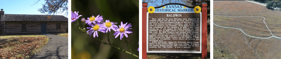
Description: Black Jack Crossing was used from the early days of the trail (1820s). The creek was called Black Jack by the Mexican wagon train drivers probably because of the Black Jack oak trees that grew along the creek.1 Santa Fe Trail travelers crossed the creek and headed Northwest toward a higher ridge of The Narrows. This ridge led through what was later the town of Palmyra and on to current N. 400 Rd. This Original Trail road can currently be driven on beginning at E. 1700 Rd/ Do. Co. 1055 and N. 400 Rd. (Editor’s Note: A set of ruts leading more directly northwest towards this ridge from the crossing were recently uncovered! – More info below!)
Location: The creek at Black Jack Crossing was located west and north west of the current Black Jack Park and Ivan L. Boyd Memorial Prairie Preserve. It is west of N. 2000 Rd, and north of US 56 Highway. Currently it is called Captain’s Creek. The creek has also been identified as possibly being Grindstone Creek. (Editor’s Note: Research regarding the creek at this location and the location of Grindstone Creek is ongoing.)
Local historians note that the creek was much larger when wagons had to cross in the days of the Santa Fe Trail.2 The creek has been much altered since then due to farming and road work. SFT travelers camped in this area since the creek was a good source of water.
___________________________________________


Above are current ariel views of the Black Jack Crossing area. The lower uses LiDar technology to remove all vegetation from view and show what is below the surface. Here, the ruts left by the wagons on the trail are easily see. The creek can be seen as well. (Also roads and bases to structures – anything severely altering that earth’s surface).
What you are seeing: The creek (to left of center); the ruts (center – currently surrounded by walking trail); newly uncovered ruts (upper); location of Black Jack Cabin (X).
___________________________________________
Camping Along the Trail: Black Jack Crossing was the usual camping place along the Trail on the second night traveling West from Independence. The Crossing was 65 miles from Independence MO.3
The First Night: The first day, travelers usually went about 35 miles4 and camped west of what is now Olathe in Johnson County KS. (No town existed in the early days of the trail, of course.) Primarily, the Lone Elm or Round Grove campground was used. It was located on the headwaters of Cedar Creek.5
Lone Elm (first known as Round Grove) campground was so named because the original large grove of trees was soon reduced to one huge elm tree.6 Trail travelers used the trees for firewood, and axels and tongues for the wagons since trees would be hard to find on the prairie. Lone Elm Campground is marked by a park located at W 167th Street and Lone Elm Road, north Olathe in Jo Co KS. It has interpretive signs, hiking trails and more. (See https://www.nps.gov/places/000/lone-elm-campground.htm for more information.)
By 1827, Elm Grove campground was also used. It was located 2 ¼ miles northwest of Lone Elm campground on Cedar Creek.7 No park exists to commemorate its site, but information is available on the internet.
The Second Night – Black Jack: Some travelers noted camping at Black Jack in their diaries. Below is an excerpt from the diary of Susan Shelby Magoffin traveling in 1846. She left Independence on June 11. Her entry for the entire day of Friday, June 12 reads:
Friday 12th “We had an early breakfast, and an early start – that is by 7 o’clock. Nothing of importance occurred til noon when we stopped for dinner at “Big Bull Creek” [Edgerton area]. The travelers call this “nooning it.” Here we had no wood; there are no trees, and we provided none in the morning so we were obliged to take a dinner of crackers with a little ham fried at the small fire of the waggoners. It went quite well though with a tin cup of shrub. At night we struck camp at “Black Jack” fourteen miles from the last[Lone Elm campground], and 49 from Ind [ependence]. The sun was an hour high when we stopped and as the wagons had not come up we could not strike camp. Being tired of the carriage I got out and took a ramble. I picked numberless flowers with which the plains are covered, and as mi alma [my love – her nickname for her husband] told me before we started, I threw them away to gather more. I wearing myself out at this, and as the tent was now up, I returned “home.”… The two companies, McMannus and the Mexicans, are on the other side of the creek to us.”8
Related Sites: The eventual town of Black Jack was located ½ mile to the east. The first settlers arrived in that area in 1852.9 The Battle of Black Jack occurred in 1856 and is often said to be the first battle of the Civil War. The battlefield was located 1/2 mile south.
NEW RUTS UNCOVERED AT SITE: In the spring of 2021, an extremely large Black Oak tree fell over, with roots attached, in the northwest part of the Black Jack site. Massive chain saws and some big equipment were required to remove the tree. It was 38” in diameter at the base and 28” in diameter at breast height and for 20 more feet! It proved to be 80 years old. This tree was located in an area of heavy vegetation, which had not been explored too closely. Working on tree removal gave time for clearing and close exploration, and a discovery was made. The tree was crossing a very wide wagon rut! Another much shallower rut could be found to the east. Once the tree and vegetation were removed, a more direct pathway to the NW, the higher ridge of The Narrows, could be seen. Clearing has continued and the plan is to regrow the prairie in this area.
M. Jardon – 7/2021
Notes
- Andreas, A. T., “Black Jack” in History of the State of Kansas: Containing a Full Account of Its Growth from an Uninhabited Territory to a Wealthy and Important State, of Its Earliest Settlements, Its Rapid Increase in Population and the Marvelous Development of Its Great Natural Resources: Also a Supplementary History and Description of Its Counties, Cities, Towns and Villages. (Chicago: 1883), pg. 355. https://archive.org/details/historyofstateof00andr/page/n3/mode2up.
- 1999, Santa Fe Trail Historical Society of Douglas County Archives, Baldwin City, Kansas.
- Gregg, Josiah, Commerce of the Prairies, ed. Max. L. Moorhead, (Norman: University of Oklahoma Press, 1974), 217.
- Ibid.
- Boyd, Roger, “SFT West Tour – Olathe Conference Center to Simmons Point,” 2017 Santa Fe Trail Association Symposium, Olathe KS.
- Ibid
- Ibid
- Magoffin, Susan Shelby, Down the Santa Fe Trail and into Mexico: The Diary of Susan Shelby Magoffin, 1846-1847, ed. Stella M. Drumm, (New Haven: Yale University Press, 1962), 6,7.
- Jackson, Hal & Simmons, Marc, The Santa Fe Trail, A Guide, (Wooston, KS: Trails Press, 2015), 115.
Sources
Andreas, A. T., “Black Jack” in History of the State of Kansas: Containing a Full Account of Its Growth from an Uninhabited Territory to a Wealthy and Important State, of Its Earliest Settlements, Its Rapid Increase in Population and the Marvelous Development of Its Great Natural Resources: Also a Supplementary History and Description of Its Counties, Cities, Towns and Villages. (Chicago: 1883), pg 355-356. Accessed March 12, 2021. https://archive.org/details/historyofstateof00andr/page/n3/mode2up
Boyd, Roger, “SFT West Tour – Olathe Conference Center to Simmons Point,” 2017 Santa Fe Trail Association Symposium, held in Olathe KS, Santa Fe Trail Historical Society of Douglas County Archives, Baldwin City, Kansas.
Gregg, Josiah, Commerce of the Prairies, ed. Max. L. Moorhead, Norman: University of Oklahoma Press, 1974, 217.
Jackson, Dorthea, A Brief History of Sites in the Black Jack Area in Douglas County, Kansas (essay collection), 1999, Santa Fe Trail Historical Society of Douglas County Archives, Baldwin City, Kansas.
Magoffin, Susan Shelby, Down the Santa Fe Trail and into Mexico: The Diary of Susan Shelby Magoffin, 1846-1847, ed. Stella M. Drumm, New Haven: Yale University Press, 1962, 6,7.